Our Results At A Glance
Building resilient communities across Rwanda through collaborative mapping and environmental conservation.
2M+
Building Footprints Mapped
100K+
Highways Mapped
320+
Youth Trained
7,000+
Trees Planted & Mapped
What We Do
We focus on ecosystem restoration, community empowerment, and sustainable development through innovative mapping solutions and environmental action.
Ecosystem Restoration & Conservation
Planting and mapping indigenous tree species for biodiversity and climate resilience.
Community-Driven Mapping
Empowering local communities with mapping skills and disaster preparedness knowledge.
Tech-Enhanced Solutions
Leveraging cutting-edge GIS technology for environmental monitoring and conservation.
Latest Updates
Stay informed about our recent achievements and ongoing initiatives in environmental mapping and conservation.
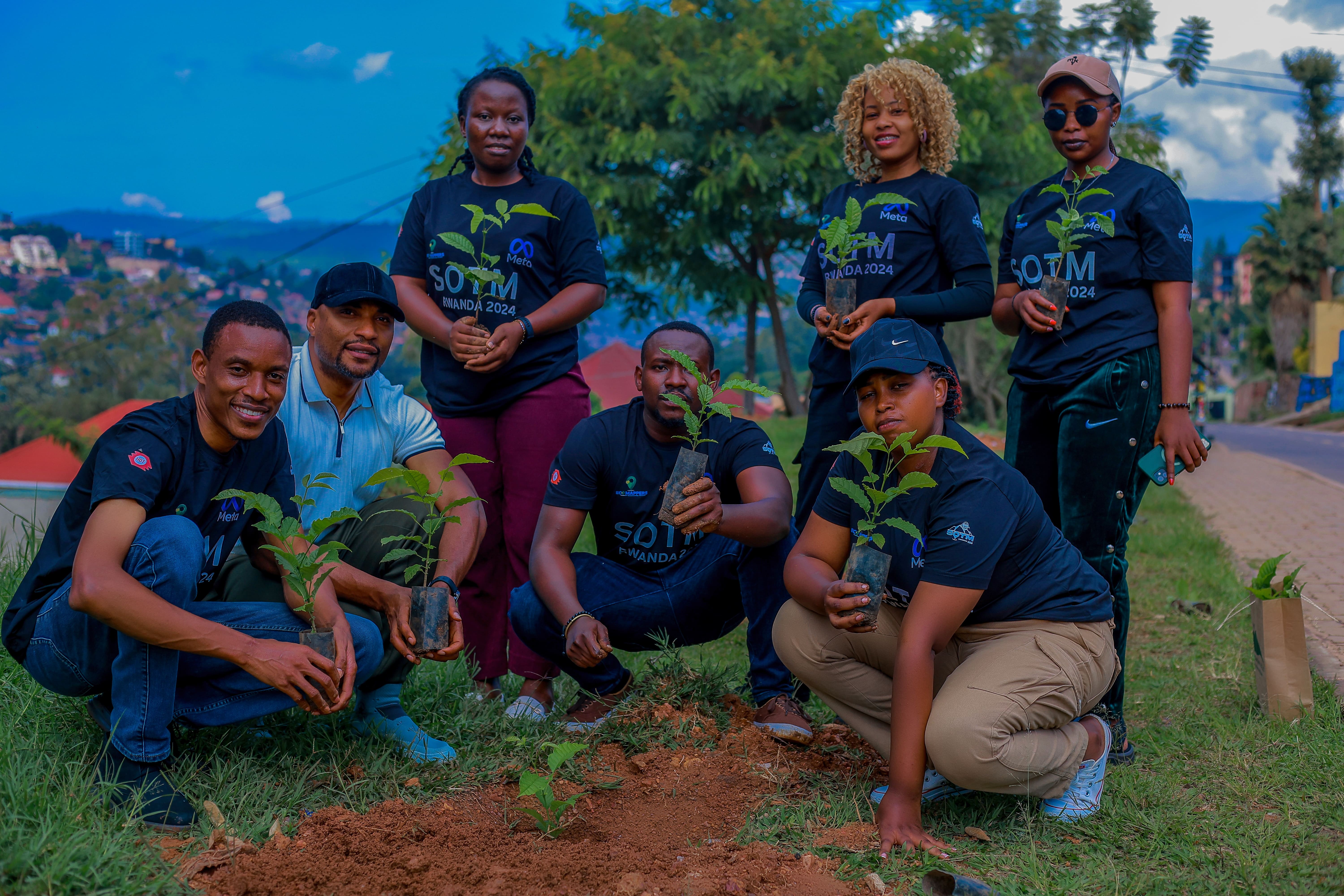
700 Trees Planted in Gasabo District
Successfully planted 700 trees of 4 indigenous species for climate resilience.
Urban Settlement Mapping
Comprehensive mapping of urban settlements across Rwanda for better planning.
High-Risk Zone Mapping
Mapping flood and landslide prone areas for disaster preparedness.
Tourism Mapping Initiative
Mapping Kigali's tourism infrastructure and attractions.
About EcoMappers
The OpenStreetMap Community of Rwanda - a community of youth mappers addressing the challenges of three planetary crises: biodiversity loss, pollution, and climate change through open geospatial data development.
Our Mission
To provide accurate, up-to-date, and accessible geospatial data through OpenStreetMap to support effective disaster response and preparedness efforts in Rwanda, empowering local communities in ecosystem restoration through humanitarian activities and providing organizations with mapping resources.
Our Vision
A resilient Rwanda where comprehensive and reliable geospatial data from OpenStreetMap enables proactive disaster response and preparedness, reduces vulnerabilities, and saves lives during emergencies while supporting environmental conservation.
Our Journey
From our founding to becoming a leading geospatial innovation hub in East Africa
Foundation
EcoMappers was founded as OpenStreetMap Community of Rwanda with a vision to address planetary crises.

Growth & Recognition
Expanded our reach and gained international recognition for environmental mapping.
Digital Transformation
Adapted to remote work and digital-first approaches during global challenges.
Climate Focus
Shifted focus to climate change adaptation and environmental monitoring.
Innovation Hub
Established as a leading geospatial innovation hub in East Africa.

Meet Our Team
Driven by passion and expertise, our team is dedicated to making a positive impact through geospatial innovation and community engagement.

Rebecca J Nyinawumuntu
Founder & Community Lead

Uwijuru Christophe
Deputy Legal Representative

Kingsley Chika Chukwu
Project Coordinator

Niyigena Jacques
Community Engagement

Umuganwa Yves
Finance Officer
Our Projects
Explore our diverse range of projects focused on environmental mapping, disaster preparedness, and community development.

Urban Wetland Mapping in Rwanda
Comprehensive mapping of urban wetlands to support conservation and sustainable development.

Ngororero District Comprehensive Mapping
Mapped 120k buildings, road networks, and water bodies with hotspot data collection.

Tea Plantation Mapping Project
Remote and field mapping of 8 tea plantations for sustainable agriculture monitoring.

Eco Climate Mapping of Kigali City
Mapping urban green spaces and climate resilience features in Kigali.
Our Partners
Trusted by leading organizations and global initiatives across Africa


Join Our Movement
Be a part of our mission to create a sustainable and resilient future through mapping, conservation, and community engagement.
Community Mapper
Help map your local community and contribute to environmental conservation through OpenStreetMap.
Time Commitment
2-4 hours/week
Skills Needed
- Basic computer skills
- Interest in geography
- Environmental awareness
Environmental Volunteer
Join our tree planting campaigns and ecosystem restoration projects.
Time Commitment
4-8 hours/week
Skills Needed
- Environmental passion
- Physical activity
- Community engagement
Technical Volunteer
Support our technical projects with coding, data analysis, or GIS expertise.
Time Commitment
4-8 hours/week
Skills Needed
- Programming
- GIS
- Data analysis
- Remote sensing
Get In Touch
Have questions about our work or want to collaborate? We'd love to hear from you.
Contact Information
info@eco-mappers.org
Send us an email anytime
Phone
+250786365700 / +250785295453
Call us during business hours
Address
Kacyiru, KG 647 St - Gift House
Visit our office
Office Hours
Mon - Fri: 8:00 AM - 5:00 PM
We are here to help